

 Brazil
 Argentina
 Bolivia
 Chile
 Colombia
 Ecuador
 Guyana
 French Guiana
 Falkland Islands (Malvinas)
 Paraguay
 Peru
 Suriname
 Uruguay
 Venezuela
 Germany
 Austria
 Belgium
 Croatia
 Denmark
 Spain
 Finland
 France
 Greece
 the Netherlands
 Hungary
 Ireland
 Iceland
 Italy
 Luxembourg
 Norway
 Poland
 Portugal
 the United Kingdom
 the Czech Republic
 Sweden
 Switzerland
 the Dominican Republic
 Fiji
Province · Mar Negro Ocidental
Amasya
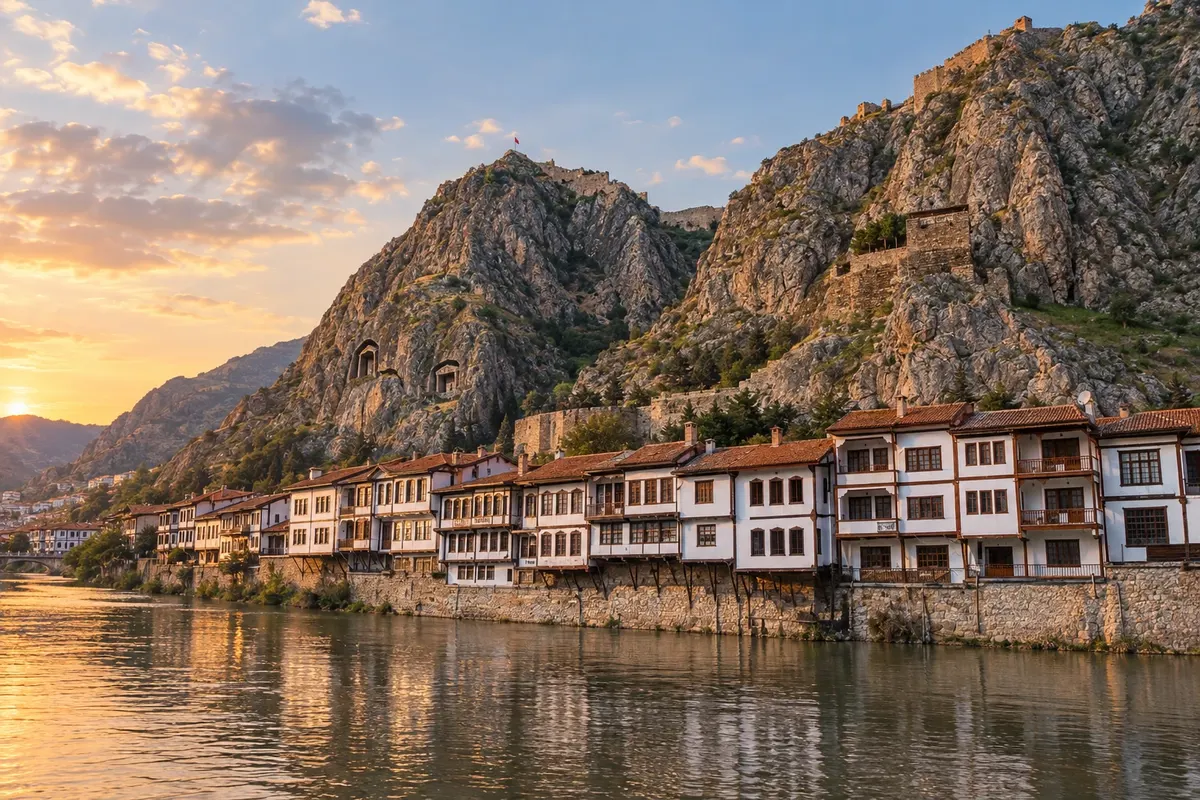
City in a valley on the banks of the river Yeşilırmak, with tombs of the kings of Pontus carved into the rock above the wooden Ottoman houses.
In the photo: Tombs of the kings of Pontus and Yalıboyu houses on the river Yeşilırmak, Amasya
Illustrative images. The pictures in this guide are illustrations based on the real place, not photographs, and may differ from it.

The province
Get to know Amasya
The province of Amasya lies inland in the Western Black Sea region, between the coast of Samsun and the Anatolian plateau. The capital, also called Amasya, occupies a narrow valley along the river Yeşilırmak, the ancient Iris, and is the part of the province that receives the most visitors.
On the slope of Mount Harşena above the river are the tombs of the kings of Pontus, cut into the rock. The geographer Strabo, who was born in the city, already described them as royal tombs. Atop the cliff, the ruins of Harşena Castle overlook the valley, and at night the tombs are lit up.
On the riverbank, the wooden houses of Yalıboyu have been restored and now house cafés, restaurants and lodging. The Hazeranlar Mansion (Hazeranlar Konağı), dating from 1872, operates as a house-museum with an art gallery and an ethnographic room. Yıldırım Beyazıt Mosque, the Burmalı Minare (Spiral Minaret) and the Sabuncuoğlu History of Medicine Museum round out a walking tour of the center. During the Ottoman period, several crown princes were sent to govern Amasya.
The region is known for the small, fragrant apples grown between Amasya and Tokat. Typical dishes include keşkek, a wheat-and-meat dish, toyga çorbası, a yogurt soup served hot or cold, and bakla dolması, with meat and broad beans. The legend of Ferhat and Şirin, a lovers’ tale from the oral tradition, has its own museum in the city.
The railway between Samsun and Sivas passes through Amasya, which still has an Ottoman-era station. The city is often visited together with Tokat or the Samsun coast.
When to go
April to June and September to October usually bring pleasant temperatures for walking along the riverbank and climbing to the castle. Summer is hot and dry in the valley. From December to February it is cold, and fog over the river is common on winter mornings and evenings.
Getting there
The nearest airport is Amasya Merzifon (MZH), about 41 km from the city, with flights to Istanbul. Another option is Samsun-Çarşamba Airport (SZF) on the coast, continuing by bus or car. Amasya is also served by intercity buses and the Samsun–Sivas railway. Confirm before purchasing tickets.
Your questions
Frequently asked questions about Amasya
Which airport should I use to go to Amasya?
Amasya Merzifon Airport (MZH) is about 41 km from the city and has flights to Istanbul. If schedules don't suit you, Samsun-Çarşamba Airport (SZF) on the coast is the alternative; from there you continue by road. Check seasonal routes when booking.
How many days should I stay in Amasya?
One full day is enough for the riverbank, the tombs of the kings of Pontus, Hazeranlar Mansion and the central mosques. Staying one night lets you see the illuminated tombs and stroll along the river at leisure. With two days you can include Tokat.
How do I visit the tombs of the kings of Pontus?
The tombs are on the slope of Mount Harşena and are reached by stairs and paths that climb from the riverbank. The ascent is steep—wear sturdy footwear. Harşena Castle is higher up and also has road access. Confirm opening times before you go.
What should I eat in Amasya?
The most mentioned dishes are keşkek, wheat cooked with meat, toyga çorbası, a yogurt soup, and bakla dolması, with meat and broad beans. Amasya apples, small and fragrant, are the region's best-known product.
Is it possible to go from Samsun to Amasya and return the same day?
Yes. Amasya is linked to Samsun by road and by rail, and a day trip can cover the historic center and the riverbank. Those who stay overnight in the city get the evening when the tombs and cliff are illuminated.