
 Brazil
 Argentina
 Bolivia
 Chile
 Colombia
 Ecuador
 Guyana
 French Guiana
 Falkland Islands (Malvinas)
 Paraguay
 Peru
 Suriname
 Uruguay
 Venezuela
 Germany
 Austria
 Belgium
 Croatia
 Denmark
 Spain
 Finland
 France
 Greece
 the Netherlands
 Hungary
 Ireland
 Iceland
 Italy
 Luxembourg
 Norway
 Poland
 Portugal
 the United Kingdom
 the Czech Republic
 Sweden
 Switzerland
 Turkey
 the United States
 Mexico
 the Dominican Republic
 South Africa
 Australia
 Fiji
 New Zealand
 Papua New Guinea
Province · Northern Canada
Northwest Territories
Yellowknife and the aurora borealis, Great Slave Lake, Nahanni National Park and the Dempster Highway to Inuvik in the Arctic.
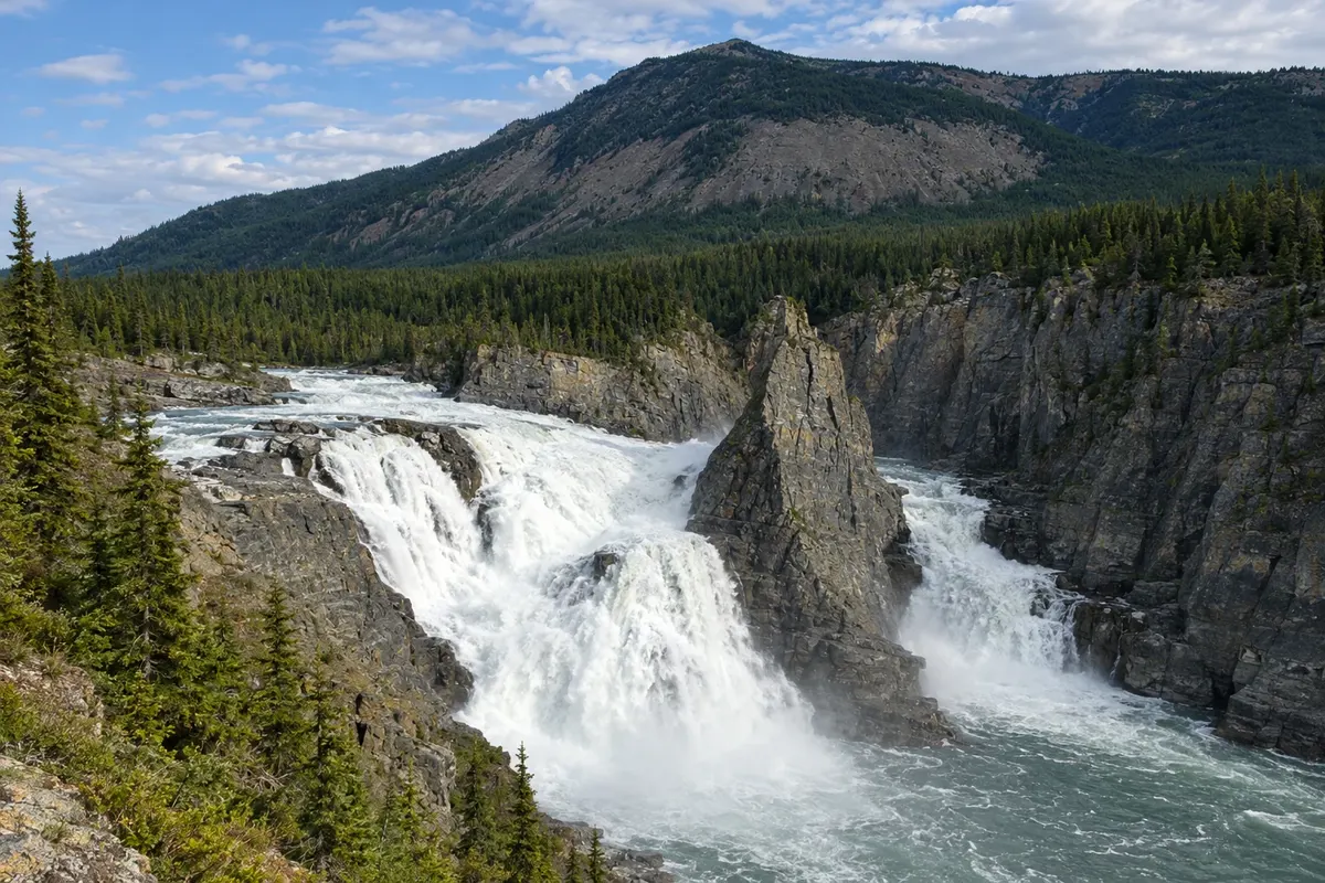
In the photo: Virginia Falls, Nahanni, Northwest Territories
Illustrative images. The pictures in this guide are illustrations based on the real place, not photographs, and may differ from it.

The province
Get to know Northwest Territories
The Northwest Territories occupy the central North of Canada, between Yukon and Nunavut, from boreal forest to tundra and the Beaufort Sea. Most residents live in Yellowknife, the capital, and in Dene, Métis and Inuvialuit communities. The territory recognizes eleven official languages.
Yellowknife sits on the north shore of Great Slave Lake, the deepest lake in North America. Its position under the zone where the aurora is most frequent and the clear winter skies have made the city one of the most sought-after places to see the aurora borealis, with camps outside town prepared to welcome visitors at night. The Old Town has houses on the rocks and houseboats in the bay.
Nahanni National Park, a UNESCO World Heritage Site, protects the South Nahanni River, with deep canyons and Virginia Falls, about twice the height of Niagara Falls. Access is by floatplane, by reservation, generally in summer. To the south, Wood Buffalo National Park, Canada’s largest park and shared with Alberta, is home to wood bison herds.
In the northwest, the Dempster Highway runs from Yukon to Inuvik at the Mackenzie River delta, and a road continues to Tuktoyaktuk on the Arctic Ocean coast. In summer, the sun barely sets in the northern part of the territory.
When to go
The aurora borealis commonly appears in Yellowknife from mid-August to early October, with lakes still unfrozen, and from mid-November through April in winter. Summer, from June to August, has very long days and is the season for Nahanni and the Dempster. During lake freeze-up and break-up, between late October and November and again in spring, some tours pause. Winter is very cold, often below −30 °C.
Getting there
Yellowknife Airport (YZF) has flights to Calgary, Edmonton and other western Canadian cities. Inuvik and Fort Simpson, the gateway to Nahanni, have regional flights. By road, the Mackenzie Highway links Alberta to Yellowknife, and the Dempster Highway, from Dawson City in Yukon, reaches Inuvik. Distances are long and services scarce: plan fuel and stops.
Your questions
Frequently asked questions about Northwest Territories
When to see the aurora borealis in Yellowknife?
There are two seasons: mid-August to early October, when you can see the aurora reflected in the lakes, and mid-November to April, with snow and long nights. Chances depend on clear skies and solar activity, and no night is guaranteed.
How many nights to book in Yellowknife to see the aurora?
Three or four nights increase your chances of getting clear skies. Tours go out at night to areas away from lights, with heated shelters. In winter, proper extreme-cold clothing is essential, and many companies rent parkas and boots.
How to get to Nahanni National Park?
There is no road to the park. Floatplane flights depart from Fort Simpson and other regional bases, generally from June to September, for day trips to Virginia Falls or for multi-day canoe trips with licensed operators. You must register your visit with Parks Canada.
Can you reach the Arctic Ocean by car?
Yes. The Dempster Highway runs from near Dawson City in Yukon to Inuvik, and from there a gravel road continues to Tuktoyaktuk on the Arctic Ocean coast. The journey is long, on unpaved roads with few services, and is generally done from June to September.