
 Brazil
 Argentina
 Bolivia
 Chile
 Colombia
 Ecuador
 Guyana
 French Guiana
 Falkland Islands (Malvinas)
 Paraguay
 Peru
 Suriname
 Uruguay
 Venezuela
 Germany
 Austria
 Belgium
 Croatia
 Denmark
 Spain
 Finland
 France
 Greece
 the Netherlands
 Hungary
 Ireland
 Iceland
 Italy
 Luxembourg
 Norway
 Poland
 Portugal
 the United Kingdom
 the Czech Republic
 Sweden
 Switzerland
 Turkey
 the United States
 Mexico
 the Dominican Republic
 South Africa
 Australia
 Fiji
 New Zealand
 Papua New Guinea
Province · Atlantic Canada
Newfoundland and Labrador
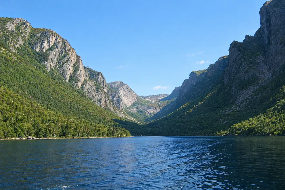
St. John's and its colorful houses, Cape Spear, the fjords of Gros Morne, the Viking site at L'Anse aux Meadows and icebergs coming from the Arctic in spring.
In the photo: Western Brook Pond, Newfoundland and Labrador
Illustrative images. The pictures in this guide are illustrations based on the real place, not photographs, and may differ from it.

The province
Get to know Newfoundland and Labrador
Newfoundland and Labrador is Canada’s easternmost province: the island of Newfoundland in the Atlantic, and Labrador on the mainland. It was a British dominion until 1949, when it joined Canada. The capital, St. John's, is among the oldest European-founded cities in North America.
St. John's has colorful houses on slopes above the harbor, like those on Jellybean Row. At the harbor entrance, Signal Hill was where Marconi received the first transatlantic radio signal, in 1901. Nearby, Cape Spear is the easternmost point of North America, with a historic lighthouse.
On the west coast, Gros Morne National Park is a UNESCO World Heritage site. It has freshwater fjords, such as Western Brook Pond, and the Tablelands, where mantle rocks are exposed at the surface. At the northern tip of the island, L'Anse aux Meadows preserves the only confirmed Viking site in North America, about a thousand years old.
Between spring and early summer, icebergs from Greenland often pass along the east and north coasts. From Witless Bay, south of St. John's, boats depart in summer to see puffins and whales.
The province has its own time zone, a half hour ahead of Atlantic Time, and a culture tied to the sea, cod fishing and traditional music, with its own way of speaking English.
When to go
Icebergs typically appear from late April to June, and puffins are in the colonies from May to August. Whales are most often seen from June to August. July and August are the mildest months and the best time for Gros Morne and the Western Brook Pond boat trips. Winter is long, with snow and strong winds, and many attractions outside St. John's open only from June to September.
Getting there
St. John's International Airport (YYT) has flights to other provinces and, in summer, to Europe. Deer Lake (YDF), on the west coast, is the gateway to Gros Morne, and St. Anthony has regional flights. Ferries connect North Sydney, Nova Scotia, to Port aux Basques and, in season, to Argentia. The Trans-Canada Highway crosses the island from Port aux Basques to St. John's, about 900 km.
Your questions
Frequently asked questions about Newfoundland and Labrador
When to see icebergs in Newfoundland?
Generally from late April to June, when icebergs from Greenland move down the coast along the corridor known as Iceberg Alley. The number varies greatly from year to year. Tracking maps published during the season show where they are.
How to get from St. John's to Gros Morne?
It’s over 600 km via the Trans-Canada Highway, about seven hours by car. Many visitors fly to Deer Lake, about an hour from the park, and rent a car there. A trip around the island usually combines both sides, with at least one week recommended.
What is L'Anse aux Meadows?
It is the archaeological site of a Viking settlement about a thousand years old, at the northern tip of Newfoundland, a UNESCO World Heritage site. The place shows remains of the original structures and reconstructions of turf houses, with interpreters demonstrating how the Norse lived.
What time zone is Newfoundland on?
The island of Newfoundland uses UTC−3:30 in winter and UTC−2:30 from March to November, a half hour ahead of the Atlantic Time used in Halifax. Most of Labrador follows Atlantic Time.