Tossa de Mar: Vila Vella and beaches
From Platja Gran de Tossa de Mar, at the foot of the walls bus from Girona (via Lloret de Mar) or from Barcelona (Estació del Nord); car about 5 hours full day easy, with a climb up to the lighthouse
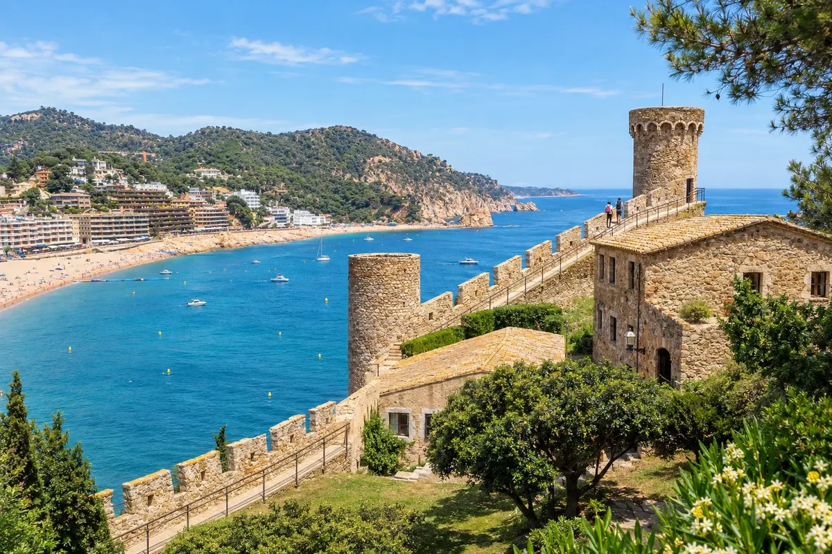
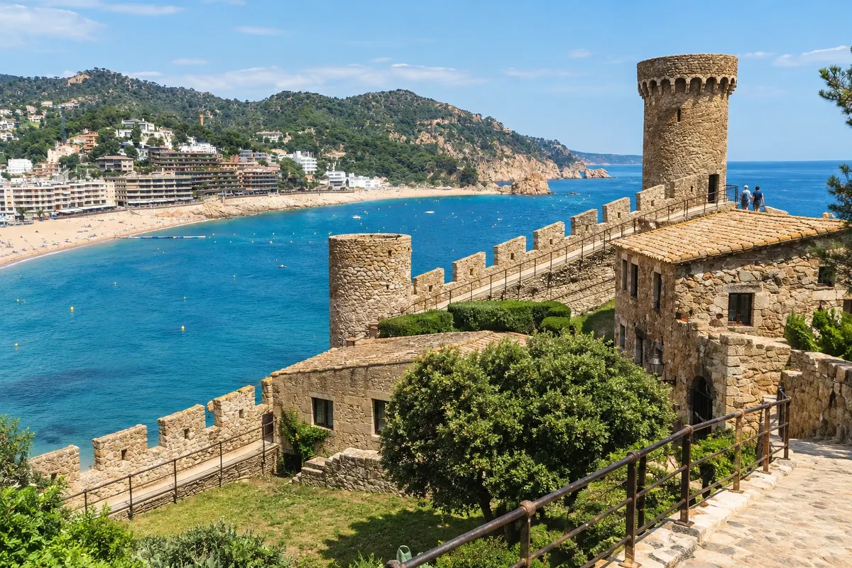
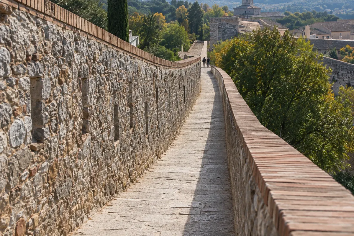
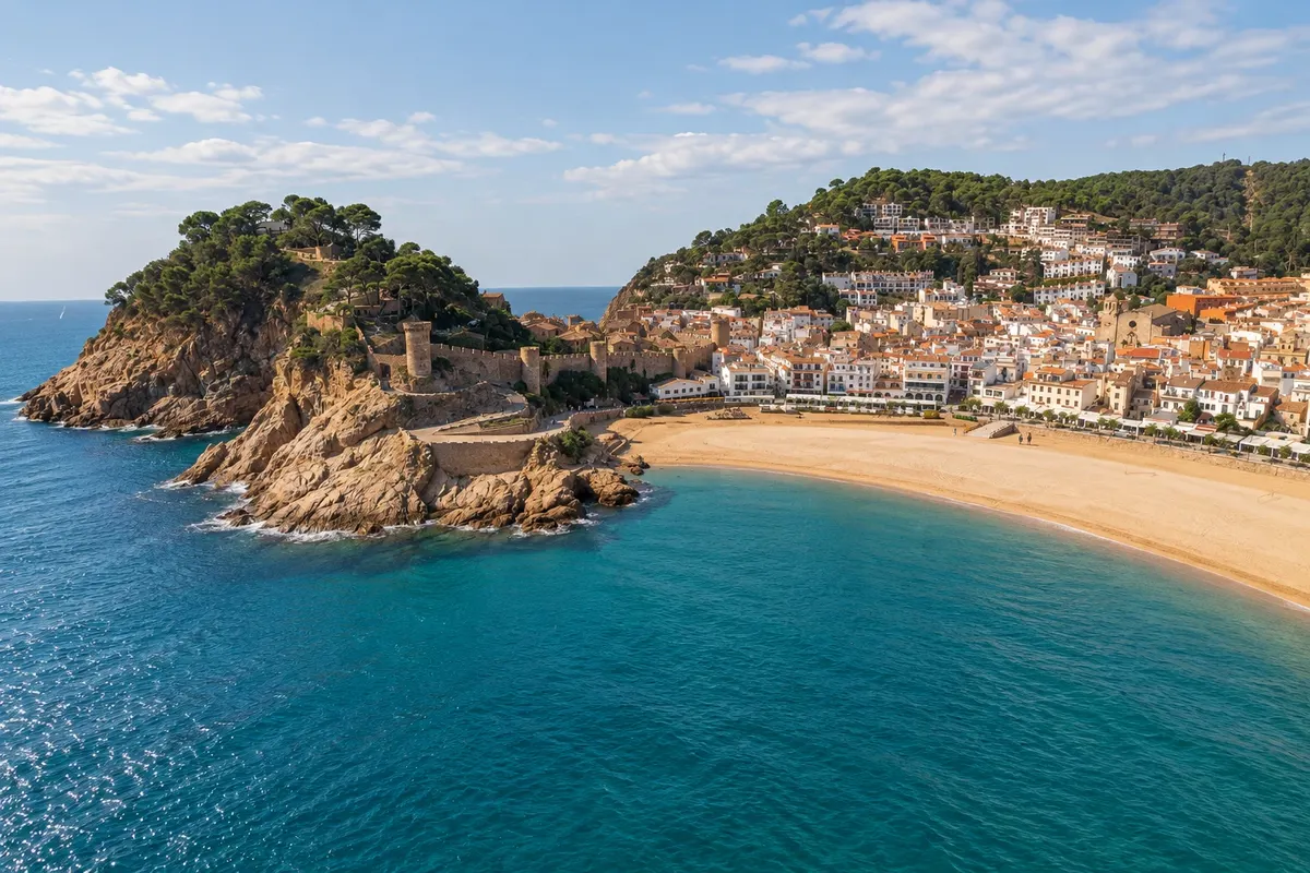
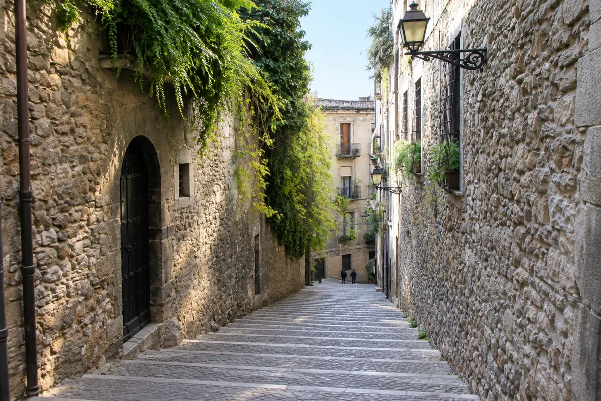
Tossa de Mar is about 100 km north of Barcelona and 40 km south of Girona, and it is the only fortified medieval village still standing on the Catalan coast. The Vila Vella, encircled by 12th–14th century walls with cylindrical towers, climbs the hill at the southern end of Platja Gran; inside are stone alleys, fishermen’s houses, the ruins of the Gothic church and, at the top, the Far de Tossa, an active lighthouse with an interpretation center about Mediterranean lighthouses. In the old Governor’s House is the Municipal Museum, with mosaics from the Roman villa dels Ametllers and a modern art collection that includes El violinista celeste by Marc Chagall, who spent seasons in the village in the 1930s. At the entrance to the Vila Vella a statue commemorates actress Ava Gardner, who filmed in Tossa in 1950. The Platja Gran, 380 m long, lies in front of the town; on the other side of the bay is the smaller Mar Menuda, good for snorkeling, and behind the walls is the pebble beach des Codolar. A camí de ronda trail leaves the lighthouse toward coves to the south.
Stops: Vila Vella, Platja Gran, Far de Tossa, Museu Municipal de Tossa de Mar, Platja de la Mar Menuda, Platja des Codolar.
Includes: Self-guided walk. Walls and lighthouse: external access free of charge; lighthouse interpretation center and Municipal Museum have separate paid admission.
Tip: The town does not have a train: from Girona the bus goes via Lloret de Mar; from Barcelona, depart from Estació del Nord and allow about 1 h 35. Check the last return, which outside summer is early. Climb up to the Vila Vella at late afternoon, when the light hits the walls.
Best time: From May to October for the beach; July and August are crowded. In winter the village is quiet and some beach services close.
Calella de Palafrugell and Llafranc via the Camí de Ronda
From Platja del Port Bo, in Calella de Palafrugell car from Girona (about 50 minutes) or bus to Palafrugell and a local connection about 4 hours morning and early afternoon easy to moderate, with stairs
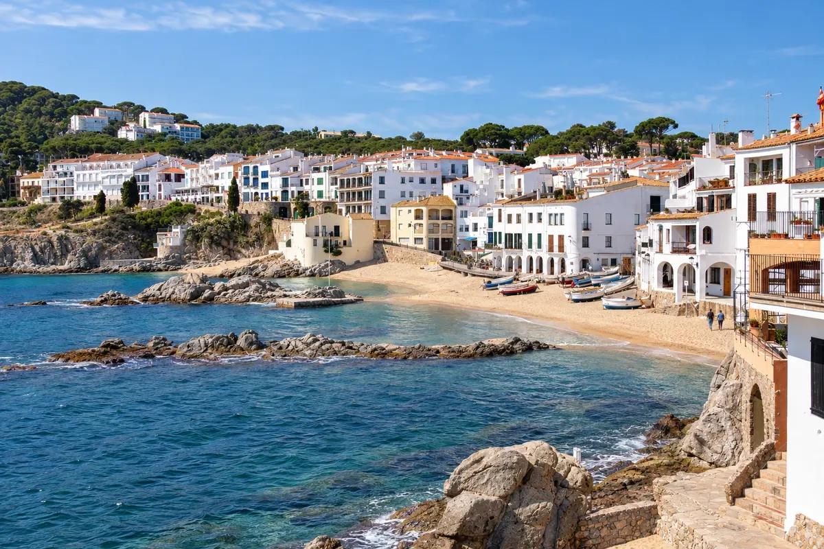
Calella de Palafrugell is the most photographed fishing village in the Baix Empordà: white houses with arcades (the voltes) above Platja del Port Bo, boats on the sand and small coves separated by rocks. From there the Camí de Ronda departs, a stone path that follows the coast, with stairs, viewpoints and sections through pine trees, to Llafranc, the neighboring village with a larger beach and a seaside promenade. The walk takes about half an hour and can be done with family. From Llafranc, a stairway or the road climbs to the Far de Sant Sebastià, a lighthouse 187 m above the sea, with a viewpoint over the whole coast, a chapel, remains of an Iberian settlement and a hotel-restaurant. If you have more time you can continue to Tamariu, the third village of the municipality of Palafrugell. On the first Saturday of July, Platja del Port Bo hosts the Cantada d'Havaneres, an evening of songs of Cuban origin that usually draws crowds.
Stops: Calella de Palafrugell, Platja del Port Bo, Camí de Ronda, Llafranc, Far de Sant Sebastià, Platja del Canadell.
Includes: Self-guided hike, no fee. Paid parking in the villages during summer.
Tip: Do the camí de ronda in the morning, before the heat, and have lunch in Llafranc. In July and August Calella’s parking fills early; there are parking areas at the village entrance. Bring water and closed-toe shoes.
Best time: From April to October. In May, June and September the path is pleasant and the beaches are less crowded.
Begur and the beaches of Sa Tuna and Aiguablava
From Begur town center, at the foot of the castle car from Girona (about 50 minutes); bus to Begur and taxi to the beaches about 7 hours full day easy; steep descents to the beaches
Begur is a village on top of a hill, a few kilometers from the sea, with a ruined castle on the summit from which you can see the coast and the Medes Islands. The center preserves indiano houses—Catalans who made fortunes in Cuba in the 19th century and returned to build colorful mansions—now part of a marked route. Each road descending from the village ends at a different cove: Sa Tuna, small, with fishermen’s houses built on the water and a stone promenade; Aiguablava, with fine sand and clear water, and the parador atop the headland; Sa Riera, the largest and most family-oriented; Platja Fonda, with dark sand, reached by a long stairway; and Aiguafreda, rockier. Sections of the camí de ronda link some of them, such as from Sa Tuna to Aiguafreda. In early September the village holds the Fira d'Indians, a street festival with Cuban music. It is one of the most sought-after areas of the Costa Brava in summer, with limited parking at the coves.
Stops: Begur, Castell de Begur, Sa Tuna, Aiguablava, Sa Riera, Platja Fonda.
Includes: Self-guided visit. Castle with open access; beaches free of charge.
Tip: In July and August arrive at the beaches before 10 a.m. or use Begur’s summer town bus to the coves, since parking fills up. Combine with Pals and Peratallada on the same day if you’re driving.
Best time: From May to September for beach; June and September offer warmer sea and fewer people.
Pals and Peratallada, medieval villages of the Empordà
From Pals, about 40 km from Girona car (about 45 minutes from Girona); bus to Pals, Peratallada only by car about 4 hours afternoon easy
Pals and Peratallada are a few kilometers apart, on the plain of the Baix Empordà, between Girona and the beaches of Begur. Pals is a village of golden stone on top of a hill: the walled center has the Torre de les Hores, a Romanesque tower remaining from the castle, stepped streets, the church of Sant Pere and the Mirador del Pedró, from where you can see the rice fields and, in the distance, the sea and the Medes Islands. Around it are rice fields that are flooded in spring and harvested in autumn; Pals rice is the base of the local dishes. Peratallada, smaller, is a medieval ensemble surrounded by walls and by a moat cut into the rock, with the castle, arcaded squares and car-free streets, full of restaurants and small shops. In the same area are Ullastret, with the largest Iberian settlement in Catalonia, and Monells. The Platja de Pals, long and with coarse sand, completes the day for those who want the sea.
Stops: Pals, Torre de les Hores, Mirador del Pedró, Peratallada, Castell de Peratallada, Platja de Pals.
Includes: Self-guided visit, free of charge; paid parking at the village entrances in summer. Ullastret requires a separate ticket.
Tip: Go at late afternoon, when the tour buses have left and the light looks nice on the stone. Leave the car in the parking lots at the entrance: you cannot drive inside the walls. On summer weekends Peratallada fills up; on weekdays it is calm.
Best time: All year. Spring, when the rice fields are flooded, and autumn, during the harvest, are the seasons with the most color on the plain.
Besalú and the medieval bridge
From Entrance of Besalú’s Romanesque bridge, over the Fluvià River bus from Girona (about 1 hour) or car (about 35 minutes) about 3 hours morning easy
Besalú is about 30 km north of Girona, on the way to the Garrotxa, and is the most visited medieval village in the province. The entrance is via the 12th-century Romanesque bridge over the Fluvià River, with seven angled arches and a tower with a gateway in the middle: the classic image of the village. Inside the old walls, paved streets lead to the Plaça de la Llibertat, with arcades and a weekly market, to the church of Sant Vicenç and to the Monestir de Sant Pere, a Benedictine church consecrated in 1003 with an arched window and lions on the façade. The rare feature is the micvé, a Jewish ritual bath from the 11th–12th centuries excavated near the river, one of the few preserved in Europe; visits are with a guide from the tourist office at set times. The village was declared a historic-artistic complex in 1966 and can be seen in a morning; in the afternoon, head to the Garrotxa volcanoes or to Banyoles.
Stops: Pont de Besalú, Miqvé de Besalú, Monastery of Sant Pere, Church of Sant Vicenç, Plaça de la Llibertat.
Includes: Self-guided visit. Micvé only with a guided tour from the tourist office, with a separate paid ticket.
Tip: Ask at the tourist office next to the bridge for the micvé visit times and reserve on arrival. The classic photo of the bridge is from the opposite bank, in the afternoon. Paid parking at the village entrance.
Best time: All year. In September there is a medieval fair; summer weekends get crowded.
Ruins of Empúries, Greek and Roman city
From L'Escala, entrance to the archaeological site by the beach car from Girona (about 45 minutes) or bus to L'Escala and walk about 3 hours morning easy, outdoors
Empúries is the only site on the Iberian Peninsula where a Greek city and a Roman city appear side by side, facing the sea, in the bay of Roses. The Greeks from Phocaea founded Emporion in the 6th century BC; the Romans arrived in 218 BC and built Emporiae above. The visit begins at the Greek city, with the wall, the agora, the temple of Asclepius and the cisterns; continues through the museum, with the statue of Asclepius and finds from the site; and climbs to the larger Roman city, with the forum, mosaic houses and the amphitheater outside the walls. Excavations are ongoing. A path along the beach links the ruins to the walled village of Sant Martí d'Empúries and to L'Escala town center, known for its anchovies. The site is the Empúries section of the Museu d'Arqueologia de Catalunya; from mid-November to mid-February it is closed on Mondays.
Stops: Empúries, Neàpolis grega, Roman city of Emporiae, Museu d'Arqueologia de Catalunya – Empúries, Sant Martí d'Empúries.
Includes: Admission to the site and the museum, with an audio guide. Guided and theatricalized visits in summer require separate reservation.
Tip: Go in the morning: the site is open and has no shade. Bring a hat and water, and finish with a swim at the beach next to the ruins. In July and August there are nighttime visits on some days; check the schedule.
Best time: From March to June and from September to October, with pleasant temperatures for outdoor walking.
Cap Roig Gardens, in Calella de Palafrugell
From Cap Roig, between Calella de Palafrugell and Palamós car (about 50 minutes from Girona) or on foot from Calella (40 minutes) about 2 hours morning or afternoon easy, with stairs
The Cap Roig Gardens cover a promontory south of Calella de Palafrugell, with the sea on both sides. They were created from 1927 by a Russian colonel, Nicolai Woevodsky, and the English aristocrat Dorothy Webster, who built a medieval-style castle and planted terraces with more than a thousand species from around the world: palm trees, cacti, pines, hydrangeas and a spring garden. Stepped paths descend to viewpoints over Cala del Golfet and Calella’s coves, and the site is maintained by a banking foundation. In July and August the garden hosts the Cap Roig Festival, with evening shows on an open-air stage; the schedule usually appears in spring and tickets are sold separately. It pairs well with the camí de ronda of Calella, which reaches the garden along the coast.
Stops: Cap Roig Gardens, Castell de Cap Roig, Cala del Golfet.
Includes: Entrance to the garden and to the exterior of the castle, with a separate ticket. Festival shows require their own tickets.
Tip: Enter early in the morning or late afternoon, when the light on the sea is best and there is less heat. On summer show nights vehicle access is restricted. Check the festival season and buy in advance if you want to attend.
Best time: From April to June, when the gardens are in bloom, and September and October. July and August for the festival.
Jardí Botànic Marimurtra, in Blanes
From Blanes, garden entrance on the top of the Sant Joan hill Rodalies train from Girona to Blanes and local bus; car (about 45 minutes) about 2 hours morning or afternoon easy, with stairs
Blanes marks the southern start of the Costa Brava and has the oldest botanical garden in the region. Marimurtra was created in the 1920s by German entrepreneur Carl Faust, who lived in Catalonia and devoted his fortune to the project. The garden occupies a cliff above the sea and brings together plants from Mediterranean and subtropical climates worldwide, with cacti, palms, bamboos and large trees. The staircase descending between cypresses to the Templet de Linné, a small temple above Cala Sa Forcanera, is the image most associated with the place, offering views of the rocks and the open sea. The route is signposted and takes about an hour and a half, with climbs. Blanes also has Platja de Blanes, the Sa Palomera rock that separates the Costa Brava from the Costa del Maresme, and a second botanical garden, Pinya de Rosa, specialized in cacti.
Stops: Jardí Botànic Marimurtra, Templet de Linné, Cala Sa Forcanera, Blanes.
Includes: Garden admission, with a separate paid ticket. There is an afternoon ticket that allows entry only after lunch.
Tip: Buy your timed ticket on the official website and go early in the morning in summer. From the Blanes train station there is a local bus to the garden; on foot it’s about a 40‑minute uphill walk. In July Blanes hosts a fireworks competition over the sea; check the dates.
Best time: All year; spring has more flowers. It closes on a few dates; check the calendar.
Sant Feliu de Guíxols and the camí de ronda to Sant Pol
From Passeig del Mar, in Sant Feliu de Guíxols bus from Girona (about 1 hour) or car (about 40 minutes) about 4 hours afternoon easy
Sant Feliu de Guíxols is a port town about 35 km from Girona, with a palm-lined seaside promenade and modernist houses called the Passeig del Mar. The historic center grew up around the Monestir de Sant Feliu de Guíxols, a Benedictine monastery with the Porta Ferrada, a 10th-century pre-Romanesque façade, and the Museu d'Història of the town, which tells the story of the cork industry. On the hilltop, the Ermita de Sant Elm has a viewpoint from which, in 1908, journalist Ferran Agulló coined the name Costa Brava. A stretch of camí de ronda of about 3 km continues north, past viewpoints and coves, to the Platja de Sant Pol and S'Agaró, a 1920s development with noucentista-style mansions and a stone seafront promenade. In summer, the Festival Porta Ferrada, one of Catalonia’s oldest, brings performances to the monastery and other stages in town.
Stops: Monestir de Sant Feliu de Guíxols, Porta Ferrada, Passeig del Mar, Ermita de Sant Elm, Platja de Sant Pol, S'Agaró.
Includes: Self-guided walk. Museu d'Història with separate admission. Festival with separate tickets.
Tip: Do the camí de ronda in the late afternoon and return by bus or taxi from S'Agaró. Platja de Sant Pol is sheltered and good for families. On festival days in July and August, the town fills up at night.
Best time: From May to October. In July and August because of the festival; in September, the beach is less crowded.
Lloret de Mar: Santa Clotilde Gardens and camí de ronda to Fenals
From Passeig de Lloret de Mar, on Platja de Lloret bus from Girona (about 50 minutes) or from Barcelona; train to Blanes and then bus about 4 hours morning and early afternoon easy
Lloret de Mar is the busiest town of the southern Costa Brava, with large hotels, long beaches and nightlife, but it still has quiet corners. The Santa Clotilde Gardens, created in 1919 on a cliff between Platja de Fenals and Cala Boadella, follow the model of Italian Renaissance gardens: terraces, stairways with sculptures, cypresses and sea views. Platja de Lloret, 1.5 km long, ends at the Castell d'en Plaja, a private house with a castle-like appearance built in the 1930s that has become a symbol of the town; on the viewpoint in front stands the Dona Marinera, a bronze statue looking out to sea. From there, a camí de ronda of about 2 km runs along the coast to Platja de Fenals, passing viewpoints and coves. The center has indiano houses and the church of Sant Romà, with modernist domes of colorful ceramics. It’s an inexpensive base with good bus connections for travelers without a car.
Stops: Santa Clotilde Gardens, Platja de Lloret, Castell d'en Plaja, Platja de Fenals, Dona Marinera, Cala Boadella.
Includes: Self-guided outing. Santa Clotilde Gardens with separate admission.
Tip: Do the camí de ronda in the morning and visit the gardens at the end of the day. Lloret is the bus interchange point for Tossa de Mar; check schedules at the bus station. In July and August the town receives a lot of young tourism and is noisy at night.
Best time: From May to October. June and September have good beach conditions with fewer crowds.
Banyoles and the Estany
From Passeig Dalmau, on the lakeside, in Banyoles bus from Girona (about 30 minutes) or car (about 25 minutes) about 3 hours morning or late afternoon easy
Banyoles is about 18 km north of Girona and has the largest natural lake in Catalonia, the Estany, 2.1 km long, formed in a depression fed by groundwater. It was the venue for rowing at the 1992 Barcelona Olympics and remains a training center for rowers. A flat path of about 8 km circles the lake, on foot or by bike, passing the pesqueres, 19th-century fishing huts built over the water on the east shore, the Romanesque church of Santa Maria de Porqueres and swimming areas with wooden platforms open in summer. There are rowboats and pedal boats for rent and an electric boat that tours the lake. Banyoles town center has the Plaça Major with arcades, a market on Wednesdays, and the Monestir de Sant Esteve, of Benedictine origin. It fits into a morning when combined with Besalú in the afternoon.
Stops: Estany de Banyoles, Pesqueres, Monestir de Sant Esteve, Plaça Major de Banyoles, Porqueres.
Includes: Walk and swim in the lake free of charge. Rowboats and pedal boats are paid separately.
Tip: Rent a bicycle in town to circle the lake in an hour. Bring swimwear from June to September: the water is cold even in summer. In the late afternoon the light faces the fishing platforms.
Best time: From April to October. June to September for swimming; autumn for the colors of the trees on the shore.
Garrotxa: volcanoes, Olot and Castellfollit de la Roca
From Can Serra area, in the Fageda d'en Jordà, between Olot and Santa Pau from Girona by car (about 1 hour); bus to Olot and local bus in summer about 8 hours full day moderate, with trails of 2 to 4 hours
La Garrotxa is the volcanic comarca of Catalonia, about 55 km from Girona via the Besalú road. The Parc Natural de la Zona Volcànica de la Garrotxa contains around 40 inactive volcanic cones; the last eruption was Croscat, about 11,000 years ago. The classic trail starts at the Can Serra parking lot, crosses the Fageda d'en Jordà, a beech forest grown over an old lava flow that turns red and gold in autumn, climbs the Volcà de Santa Margarida, with a small chapel in the middle of the grass‑covered crater, and ends at the Croscat, cut through by former stone extraction, exposing layers of lapilli. It is about 10 km and takes 3 to 4 hours, with a shorter section that follows only the beech. Olot, the capital, has modernist houses, the Museu dels Volcans and four volcanoes inside the town, such as Montsacopa, with a chapel at the top. On the way back, stop at Castellfollit de la Roca: the village sits atop a basalt cliff about 50 m high and 1 km long, formed by two lava flows; the viewpoint across the Fluvià river gives the full view, and the old church stands on the cliff’s tip. Santa Pau, a medieval village with a porticoed square, completes the day.
Stops: Parc Natural de la Zona Volcànica de la Garrotxa, Fageda d'en Jordà, Volcà de Santa Margarida, Volcà del Croscat, Olot, Santa Pau, Castellfollit de la Roca.
Includes: Trails on your own, no fee. Can Serra parking is paid. Museu dels Volcans requires a separate ticket.
Tip: In autumn, on weekends, the Fageda gets crowded and the Can Serra parking closes when full: arrive early or use the bus that runs from Olot and Santa Pau on those days. Bring hiking shoes and water; there is little cell signal on the trails.
Best time: October and November for beech colors; spring for everything green. In summer the trails are hot.
Boat trip along the southern coast: Tossa, Lloret and Blanes
From Platja Gran de Tossa de Mar or Platja de Lloret de Mar direct boarding on the beach from 40 minutes to 1 h 30, depending on the section morning or afternoon easy
The simplest way to see the Costa Brava as it was named—wild and rocky—is from the sea. Sightseeing boats connect Blanes, Lloret de Mar and Tossa de Mar along the southern coast, stopping at beaches and passing coves unreachable by land, such as Cala Canyelles, Cala Giverola and the cliffs between Lloret and Tossa. The boats have glass bottoms and on clear-sea days you can see the rocky seabed and fish; passengers can get off at a beach and take another boat later, using the route as transport. The Lloret–Tossa leg takes about 40 minutes and offers the most varied scenery, arriving in front of the Vila Vella walls. Further north, similar trips depart from Palamós, from Roses to the Cap de Creus and from L'Estartit to the Medes Islands, a marine reserve with a rich seabed for snorkeling. Boats usually run from spring to autumn, with more departures in July and August, and they do not operate in rough seas or during tramuntana.
Stops: Platja Gran de Tossa de Mar, Platja de Lloret de Mar, Blanes, Cala Giverola, Cala Canyelles.
Includes: Boat ticket paid separately, per segment or round trip.
Tip: Buy on the beach itself, at the company kiosks, and check the time of the last return before disembarking in a cove. Go in the morning, when the sea is usually calmer. Bring sunscreen and a light windbreaker: it can be windy on the boat.
Best time: From May to September; in July and August there are departures all day. Outside that season, check whether the service is running.


 Brazil
 Argentina
 Bolivia
 Chile
 Colombia
 Ecuador
 Guyana
 French Guiana
 Falkland Islands (Malvinas)
 Paraguay
 Peru
 Suriname
 Uruguay
 Venezuela
 Germany
 Austria
 Belgium
 Croatia
 Denmark
 Finland
 France
 Greece
 the Netherlands
 Hungary
 Ireland
 Iceland
 Italy
 Luxembourg
 Norway
 Poland
 Portugal
 the United Kingdom
 the Czech Republic
 Sweden
 Switzerland
 Turkey
 the United States
 Mexico
 the Dominican Republic
 South Africa
 Australia
 Fiji