
 Brazil
 Argentina
 Bolivia
 Chile
Chile Colombia
 Ecuador
 Guyana
 French Guiana
 Falkland Islands (Malvinas)
 Paraguay
 Peru
Peru Suriname
 Uruguay
 Venezuela
 Germany
 Belgium
 Denmark
 Spain
Spain France
 Greece
 the Netherlands
 Ireland
 Italy
Italy Luxembourg
 Portugal
 the United Kingdom
 Sweden
 Switzerland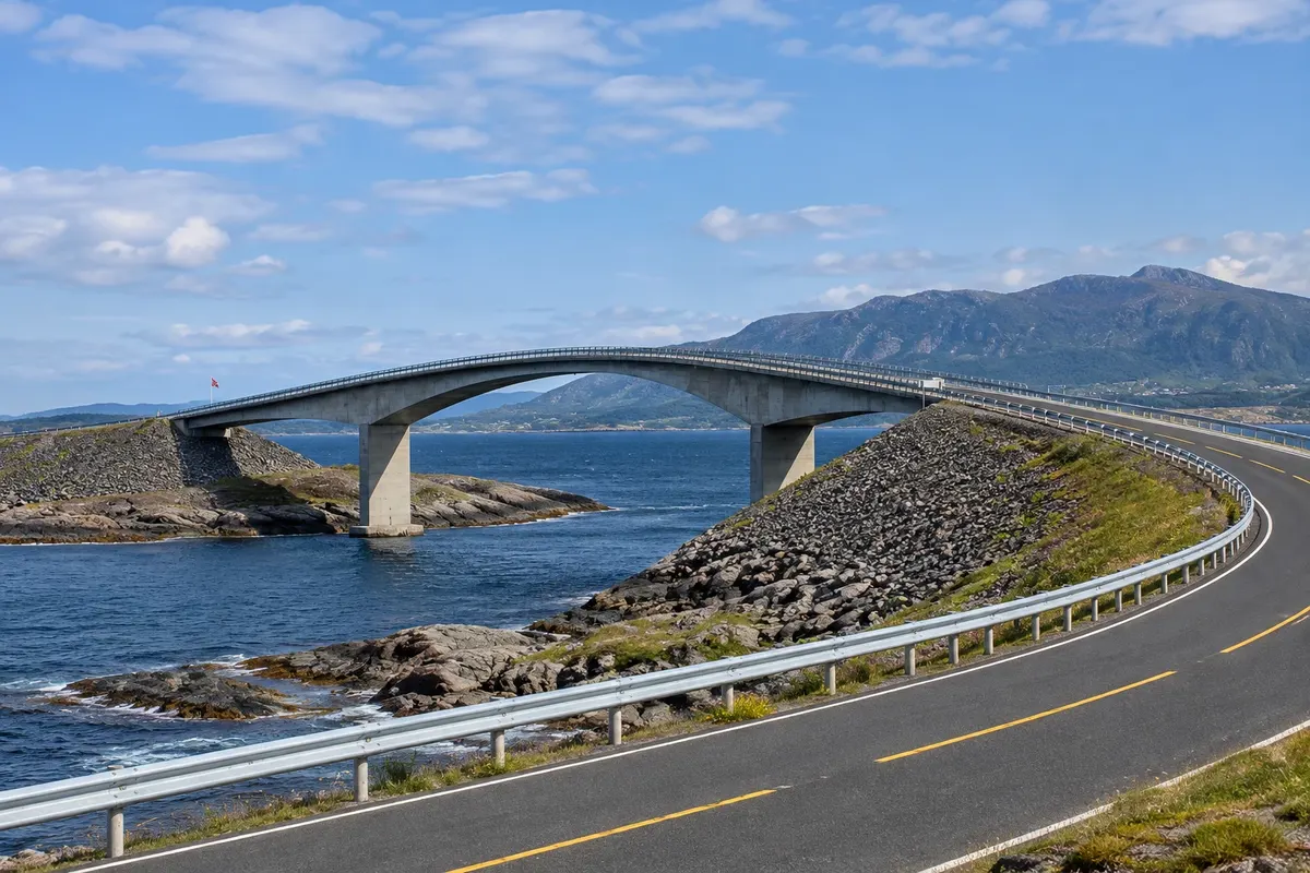
Scenic road · Molde, Møre e Romsdal
Atlanterhavsveien
The Estrada do Atlântico: 8.3 km of causeways and eight bridges over islets and reefs between Vevang and Averøy, featuring the curved Storseisundet bridge, viewpoints and the Eldhusøya boardwalk over the sea.
Illustrative images. The pictures in this guide are illustrations based on the real place, not photographs, and may differ from it.

Discover
About Atlanterhavsveien
The Atlanterhavsveien, the Estrada do Atlântico, is part of road 64 and links the mainland at Vevang to the island of Averøy, passing a string of islets and reefs at the mouth of Hustadvika, an exposed stretch of sea on the coast of Møre e Romsdal. It is 8.3 km of causeways and eight bridges that rise and fall over the water, with the ocean on one side and islands and mountains on the other.
The best-known bridge is Storseisundet, the largest, about 260 metres long with a curve that, from certain angles, appears to end in midair. It is the image used in photos of the road and in car adverts. The other bridges are smaller, and there are parking areas between them.
The road is part of the National Tourist Routes. At Eldhusøya, near Storseisundet, a steel boardwalk loops around the islet above the rocks with views of the bridges and the sea; there is a café and toilets. At other spots, fishing platforms let people cast lines into the sea, a common local pastime.
The scenery changes with the weather. On calm summer days the water is clear and seals and seabirds can be seen. In autumn and winter storms the waves crash over the causeways and onto the road, and many people come just to watch from the car parks.
Before you go
Practical information
Cidade Turismo reviews its information regularly, but something may have changed. Check with the place before planning your trip.
How much time to set aside
1 to 2 hours with stops; about 1 hour by car from Molde each way.
Best time
From June to August, on clear, calmer days for the stops and the boardwalk. From October to February, storms often bring large waves; in strong winds the road can have restrictions. Check conditions before you go.
How to get there
It is about a 1-hour drive from Molde along road 64 toward Kristiansund. There are buses between Molde and Kristiansund on that road but with limited schedules; a car is the most practical option.
Tip
Stop at Eldhusøya and walk the boardwalk before continuing. For the classic Storseisundet photo, use the car park on the Averøy side. Combine this with Bud and Trollkirka on the same day.
Official website
Get your questions answered
Frequently asked questions about Atlanterhavsveien
How long is the Estrada do Atlântico?
About 8.3 km, with eight bridges between Vevang and Averøy.
Does the road have a toll?
Toll rules may change; check before you go.
Where to stop on the Estrada do Atlântico?
At Eldhusøya, with a boardwalk, café and restrooms, and at the parking areas near the Storseisundet bridge.
Is it worth visiting in winter?
Yes, to see storm waves, but with strong winds the road may have restrictions.