
 Brazil
 Argentina
 Bolivia
 Chile
Chile Colombia
 Ecuador
 Guyana
 French Guiana
 Falkland Islands (Malvinas)
 Paraguay
 Peru
Peru Suriname
 Uruguay
 Venezuela
 Germany
 Belgium
 Denmark
 Spain
Spain France
 Greece
 the Netherlands
 Ireland
 Italy
Italy Luxembourg
 Portugal
 the United Kingdom
 Sweden
 Switzerland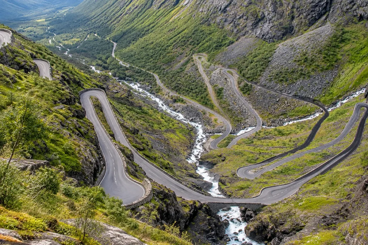
Scenic road and viewpoint · Geiranger, Møre e Romsdal
Trollstigen
A Escada dos Trolls: the road that climbs in 11 tight hairpins up a mountain wall between Åndalsnes and Valldal, with the Stigfossen waterfall and viewing platforms at the top.
Illustrative images. The pictures in this guide are illustrations based on the real place, not photographs, and may differ from it.

Discover
About Trollstigen
Trollstigen is the mountain road that connects the Isterdalen valley, near Åndalsnes, to the plateau that drops down toward Valldal and Geiranger. The best-known section climbs a cliff face with 11 tight hairpins, gradients of about 9% and the Stigfossen waterfall falling beside it, beneath a stone bridge. The road was opened in 1936 after eight years of work, and is part of the National Tourist Routes.
At the top, at around 850 metres, is the visitor centre with a restaurant and shop, and a path leads to the viewing platforms, made of metal and concrete, that project over the valley. From there you can see the road's curves below, the waterfall and the surrounding mountains, with names such as Rei, Rainha e Bispo.
Heading south, the road crosses the plateau and the Valldal valley to the Linge–Eidsdal ferry, from where the Estrada da Águia leads to Geiranger. Trollstigen and Geiranger together form the West Fjords Route, driven by car or by tour bus in summer.
The road usually opens in late May or in June and closes in October, depending on snow. Early in the season, snow walls line the asphalt at the top.
Before you go
Practical information
Cidade Turismo reviews its information regularly, but something may have changed. Check with the place before planning your trip.
How much time to set aside
1 to 2 hours at the top, including the platforms and the visitor centre; about 1.5 hours' drive from Geiranger.
Best time
From June to September, when the road is usually open. Early in the season there is snow at the top; the waterfall usually has more water in June. Check the road opening before you go.
How to get there
About 1.5 hours from Geiranger via road 63, the Eidsdal–Linge ferry and the Valldal valley. From Åndalsnes it is about 15 km. In summer, tour buses operate the route.
Tip
Drive the route from south to north, from Geiranger toward Åndalsnes, so you descend the hairpins with the valley ahead. Stop at the top before descending, and do not stop on the road between the curves.
Official website
Get your questions answered
Frequently asked questions about Trollstigen
When is Trollstigen open?
It usually opens between late May and June and closes in October, depending on the snow. Check before you go.
Can you go from Geiranger to Trollstigen on the same day?
Yes. It's about 1 hour 30 minutes by car, with the ferry from Eidsdal to Linge. Many do a round trip, or continue on to Åndalsnes and Molde.
Is the road difficult to drive?
It's narrow and has tight bends, with buses in summer. Drive slowly and use the pull-outs.
Are there facilities at the top?
Yes, a visitor center with a restaurant, shop, restrooms and viewing platforms.