Stavanger and Preikestolen

Rogaland · Norveška

Stavanger and Preikestolen

The oil city with white wooden houses, gateway to the Lysefjord, the Preikestolen hike, the Kjeragbolten and the swords of Hafrsfjord.

Westfjords

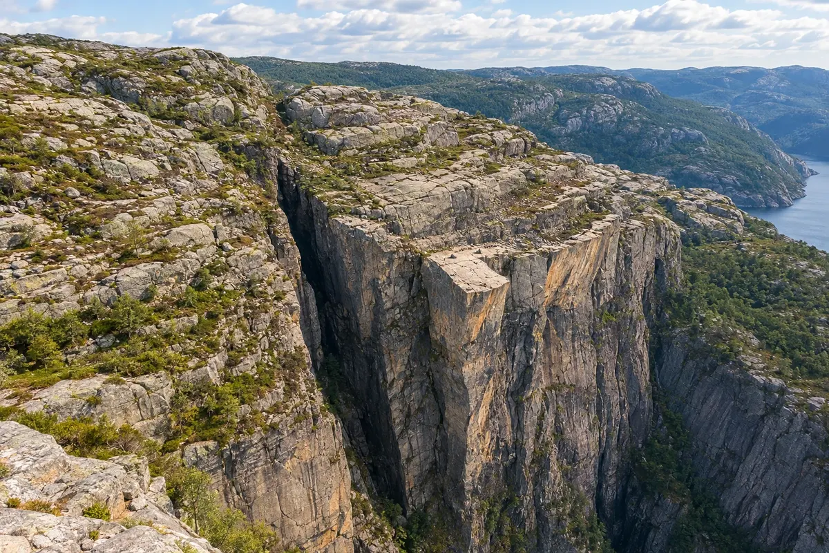
Na fotografiji: Preikestolen

Illustrative images. The pictures in this guide are illustrations based on the real place, not photographs, and may differ from it.

Na voljo v trgovini Google Play Pošljite svoje fotografije

Spoznajte kraj

Pokrajina, ki jo doživite
v svojem ritmu.

Stavanger is in southwest Norway, on the Rogaland coast, and is the country's oil capital: companies that operate in the North Sea have been based here since the 1970s. Before that, the city lived from herring fishing and canned sardine factories, and that history shows around the centre by the harbour of Vågen.

On the west side of the harbour, Gamle Stavanger brings together about 170 white wooden houses from the 18th and 19th centuries, on cobbled streets, with the Museu das Conservas in a former factory. On the other side, Øvre Holmegate has brightly painted facades. The 12th-century cathedral is the oldest in Norway to retain its medieval form, and the Petroleum Museum on the waterfront tells the other half of the city's story.

To the east, across the Boknafjord, lies the Lysefjord, 42 km long between granite cliffs. Above it sits Preikestolen, the Pulpit, a rock plateau 604 metres above the water, reached by a trail of about 4 km. At the fjord's head, Kjeragbolten, a rock wedged in a crevice about 1,000 metres up, is the region's most demanding hike. South of the city, the three bronze swords of Hafrsfjord commemorate the battle that, according to tradition, united Norway.

The hike is usually done from April to October; in winter, only with a guide. The Jæren coast to the south has sandy beaches used in summer.

This destination brings together 1 city: Stavanger.

Delite: WhatsApp
Delite svoja popotniška doživetja s fotografijami Pošljite fotografije vsakega kraja, ki ste ga obiskali. Največje število fotografij na kraj: 5.

Ena destinacija, več poti

Mesta na tej poti

Začnite v enem mestu ali v načrt poti vključite več mest.

Stavanger and Preikestolen – lega
Stavanger

Obrisi: © Kartverket (CC BY 4.0), meje iz leta 2024, podatki o obali: geoBoundaries. Priredba: Cidade Turismo.

Kako do tja:Stavanger and Preikestolen

✈ Stavanger lufthavn, Sola (SVG), kraj: Sola· 14 km do cilja (Stavanger)

Confirm before booking. Sola airport is about 14 km from the centre. From Bergen, the fast boat and coastal bus take four to five hours; from Oslo, the train via Kristiansand takes around eight hours.

Doživite kraj

Kaj početi – Stavanger and Preikestolen

Gamle Stavanger (Old Stavanger)
Stavanger · Rogaland · Zgodovinska mestna četrt

Gamle Stavanger (Old Stavanger)

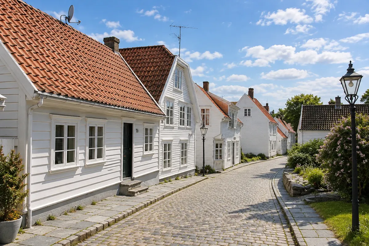
The old town of Stavanger: about 170 white wooden houses from the 18th and 19th centuries on cobbled streets on the west side of the harbor, with the Museu das Conservas in a former sardine factory.

Norwegian Petroleum Museum (Norsk Oljemuseum)
Stavanger · Rogaland · Muzej

Norwegian Petroleum Museum (Norsk Oljemuseum)

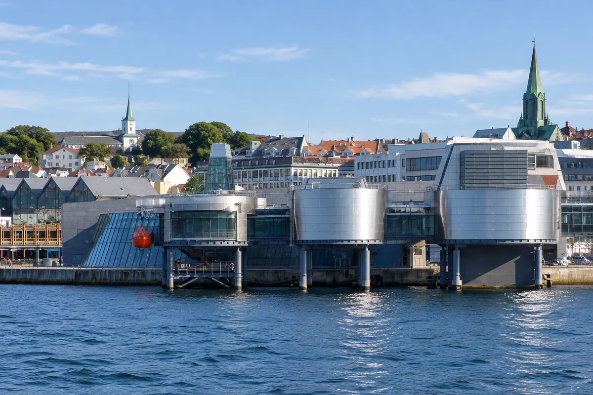
The Museu do Petróleo da Noruega, in a building on the edge of Stavanger's harbor that resembles a platform: the history of exploitation in the North Sea, models of platforms, diving and the storm room.

Stavanger Cathedral (Stavanger domkirke)
Stavanger · Rogaland · Stolnica

Stavanger Cathedral (Stavanger domkirke)

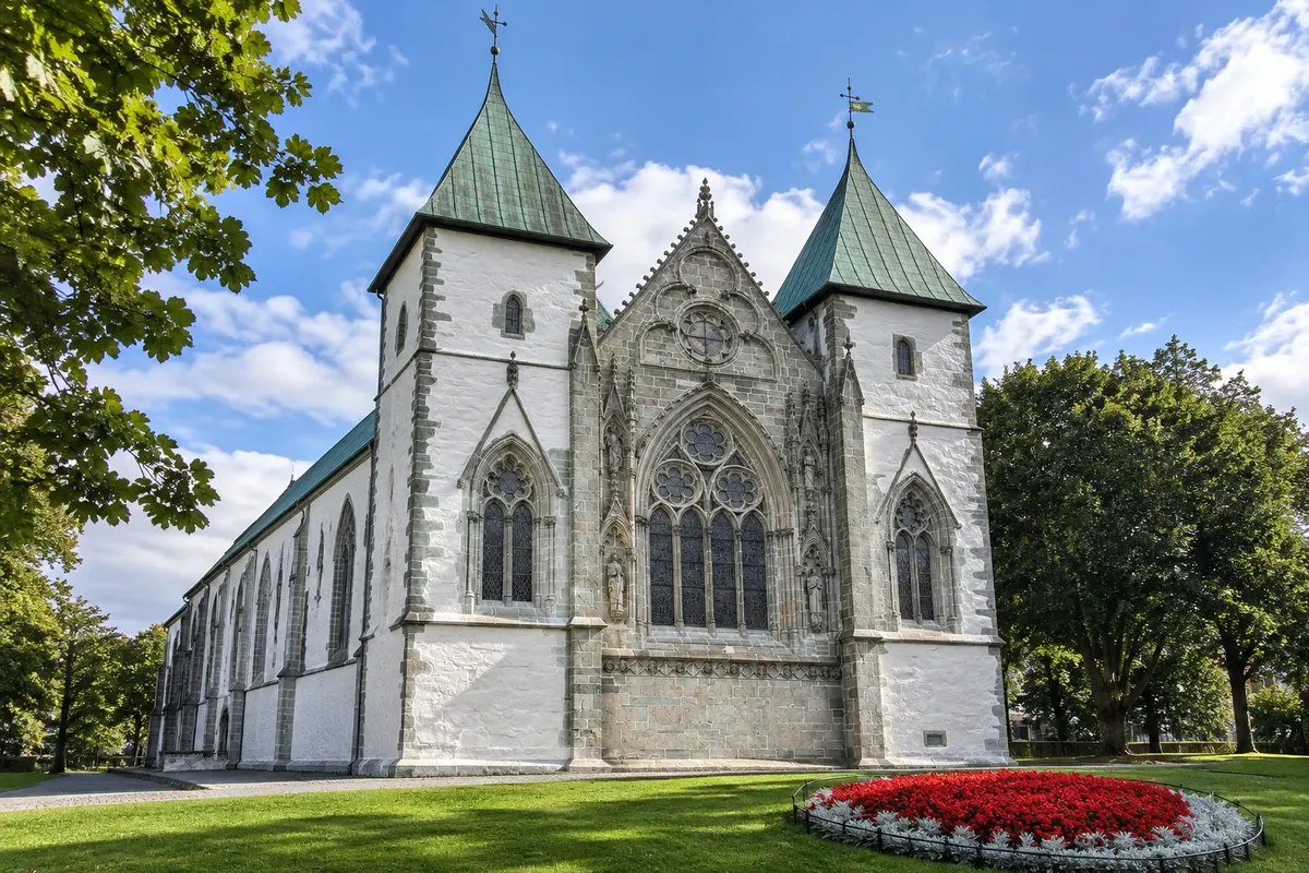
Stavanger Cathedral, begun around 1125: a stone Romanesque nave, a Gothic choir and a carved Baroque pulpit, on the square by the lake Breiavatnet in the city center.

Preikestolen (Pulpit Rock)
Stavanger · Rogaland · Trail and viewpoint

Preikestolen (Pulpit Rock)

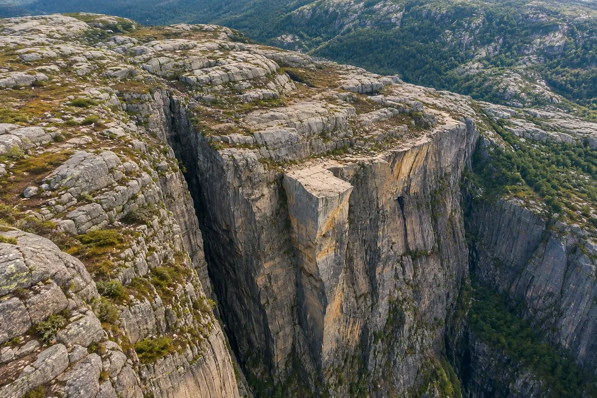
The Pulpit: a nearly flat, square rock platform about 604 metres above the Lysefjord, reached by a mountain trail of around 4 km from the Preikestolhytta car park.

Stavanger and Preikestolen – prikaži dodatne kraje (3)
Lysefjord (Lysefjorden)
Stavanger · Rogaland · Fjord

Lysefjord (Lysefjorden)

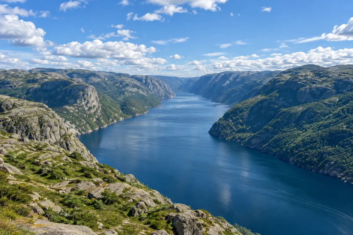
The 42-km fjord between granite walls east of Stavanger, with Preikestolen and Kjerag above, waterfalls such as Hengjanefossen and the village of Lysebotn at the end; explored on boat tours.

Kjeragbolten
Stavanger · Rogaland · Trail and rock formation

Kjeragbolten

A rock wedged in a crevice between two cliff faces about 1,000 meters above the Lysefjord, on the summit plateau of Kjerag; the trail starts at Øygardstøl above Lysebotn and is usually done in summer.

Sverd i fjell (Swords in Rock)
Stavanger · Rogaland · Monument

Sverd i fjell (Swords in Rock)

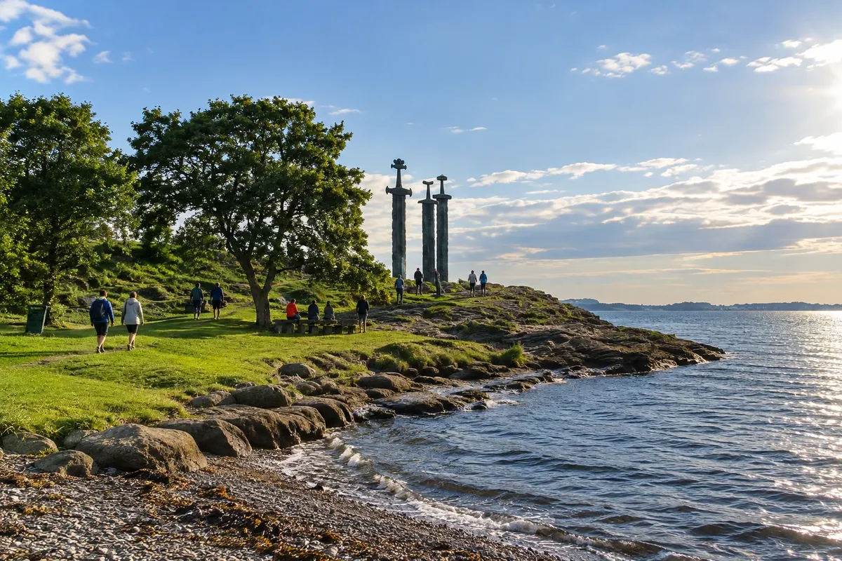
Three 10-metre bronze swords planted in the rock at the edge of Hafrsfjord, south of Stavanger, in memory of the battle in which, according to tradition, Haroldo Cabelos Belos united Norway.

Kaj izbrati pred odhodom

Izleti – Stavanger and Preikestolen

Izhodišče, trajanje, potek, vključene storitve in okvirna cena vsakega izleta.

Gamle Stavanger

Odhod: Stavanger It sits on the west side of the harbour, a 5-minute walk from the cathedral and the ferry terminal. 1 to 2 hours, including the Canning Museum. during the day depending on the route chosen

Gamle Stavanger, the old town, occupies the slope on the west side of the Vågen harbour, a few minutes from the cathedral. About 170 wooden houses, almost all white, were built between the late 18th and early 19th centuries, when the town lived off herring and maritime trade. In the 1950s the municipality planned to replace them with new buildings; a local architect persuaded the councillors to preserve them, and the ensemble remains as it is, one of the major clusters of wooden houses in northern Europe. The streets, such as Øvre Strandgate and Nedre Strandgate, are narrow, paved with stone, with iron lamps, white fences and small gardens with flowers in summer. The houses are private residences, and the walk is along the street, looking at the façades, gates and views over the harbour.

Kraji na poti: Gamle Stavanger.

Vključuje: Arrange access to the site and transport separately. Guided activities and tickets have their own conditions.

Nasvet: Enter via Øvre Strandgate and descend to the lower streets near the water. Respect residents' privacy: the houses are lived in. Finish at Øvre Holmegate on the other side of the harbour for a coffee.

Najboljši čas za obisk: From May to September, when gardens are in bloom and there is light late into the evening.

Norsk Oljemuseum

Odhod: Stavanger It is located at the tip of the Vågen harbour, a 10-minute walk from the cathedral and the city centre From during the day up to 2 hours. during the day depending on the route chosen

The Norsk Oljemuseum, the Oil Museum, tells how the discovery of oil in the North Sea in the late 1960s changed Norway and Stavanger. The building, on the tip of the harbor, mixes blocks of granite and steel cylinders that evoke offshore platforms, and it overlooks the fjord and the islands. The exhibition explains how oil formed on the sea floor, how it was found and how it is extracted, with scale models of platforms, real equipment and a cross-section of a drilling. One section covers workers’ life at sea, with two-week shifts, reconstructed sleeping quarters and messes, and the accidents that marked the industry’s history.

Kraji na poti: Norsk Oljemuseum.

Vključuje: Arrange access to the site and transport separately. Guided activities and tickets have their own conditions.

Nasvet: Start with the introductory film and then visit the scaled platforms. With children, allow time for the escape tunnel and the Geopark outside.

Najboljši čas za obisk: All year round

Stavanger Cathedral

Odhod: Stavanger It is located in the center, by the Breiavatnet lake, a 5-minute walk from the train station and 30 minutes to 1 hour. during the day depending on the route chosen

Stavanger Cathedral was begun around 1125, when the town became a bishopric, and it is dedicated to Saint Swithun, an English saint. It is the oldest cathedral in Norway that retains its medieval appearance. The nave, built of gray stone, has thick columns and rounded arches in the Anglo-Norman Romanesque style, brought by English builders. The choir was rebuilt in the Gothic style after a fire at the end of the 13th century, with tall windows and two small towers on the east facade, the most photographed side of the church. The choir’s colorful stained-glass windows are 20th century and depict scenes from the life of Christ.

Kraji na poti: Stavanger Cathedral.

Vključuje: Arrange access to the site and transport separately. Guided activities and tickets have their own conditions.

Nasvet: Walk around the outside to see the east façade, with the Gothic chancel and the two towers. From the lake side, the view of the cathedral reflected in the water is the prettiest.

Najboljši čas za obisk: During the day, outside Mass times

Preikestolen

Odhod: Stavanger From Stavanger, by car through the Ryfast undersea tunnel to Jørpeland and the parking About 4 to 5 hours round trip, including time at the top. during the day depending on the route chosen

Preikestolen, the Pulpit, is a granite platform roughly 25 by 25 meters that juts out over the Lysefjord, about 604 meters above the water. Its almost square shape and straight edge come from a natural crack in the rock, caused by ice thousands of years ago. It is very popular, and the view spans the fjord to the east and west, with the granite mountains of Rogaland. The trail begins at the Preikestolhytta parking area, near Jørpeland, and is about 4 km each way, with 500 meters of ascent. The path is marked and mixes sections of stone steps, smooth rock, small lakes and flat boggy areas with wooden boardwalks. It takes about 2 to to ascend and a little less to descend; in total, allow 4 to 5 hours.

Kraji na poti: Preikestolen.

Vključuje: Arrange access to the site and transport separately. Guided activities and tickets have their own conditions.

Nasvet: Wear hiking boots or trail shoes, bring water, a snack and a jacket: it is windy and colder at the top. Climb the slope to the left of the Pulpit for the photo from above and enjoy the platform sitting, away from the edge.

Najboljši čas za obisk: From April to October, when the trail is usually free of snow

Lysefjorden

Odhod: Stavanger Tours depart from the pier in central Stavanger, by the Vågen harbour About 3 hours for the round-trip boat tour departing from Stavanger during the day depending on the route chosen

The Lysefjord, the fjord of light, is about 42 km long and begins at Forsand, east of Stavanger. The name comes from the light-colored granite of the cliffs, which rise almost straight from the water to over a thousand meters. There is no road along the shores, and almost all villages on the fjord are reached only by boat. Boat tours depart from central Stavanger and take about three hours round trip. The boat passes islands, the Lysefjord bridge and enters between the cliffs to come underneath Preikestolen, 604 meters above. Further on, it stops by the Hengjanefossen waterfall, close enough to feel the spray, and passes the Vagabonden cave, where, according to local story, a wanderer once lived.

Kraji na poti: Lysefjorden.

Vključuje: Arrange access to the site and transport separately. Guided activities and tickets have their own conditions.

Nasvet: Combine the boat trip with the Preikestolen hike on different days: one shows the Pulpit from below, the other the fjord from above. Bring a jacket for the deck, even on sunny days.

Najboljši čas za obisk: From May to September, with more boat departures and the ferry to Lysebotn operating

Kjeragbolten

Odhod: Stavanger From Stavanger, it is about by car during the day to Øygardstøl, via road d 5 to 7 hours round trip. during the day depending on the route chosen

Kjeragbolten is a rock block of about 5 cubic meters wedged in a narrow fissure between two rock walls, high on Mount Kjerag near the head of the Lysefjord. Below it the fissure opens into an almost 1,000-meter drop to the water. Many people climb onto the rock for the photo, but the hike is also worthwhile for the trail and the fjord view without needing to step on the boulder. The trail starts at Øygardstøl, a restaurant and visitor center at the top of the road that descends in bends to Lysebotn. It is about 5.5 km each way, with three steep climbs, sections with fixed chains on the rock for support, and granite plateau stretches. Round trip, allow 5 to 7 hours.

Kraji na poti: Kjeragbolten.

Vključuje: Arrange access to the site and transport separately. Guided activities and tickets have their own conditions.

Nasvet: Go with hiking footwear, layered clothing, water and food. You don't need to climb onto the rock to enjoy the trail. Respect the return time so you don't descend in the dark.

Najboljši čas za obisk: From June to September, when the road to Øygardstøl and Lysebotn is usually open and the trail is free of snow.


Prikaži še 1 izlet

Sverd i fjell

Odhod: Stavanger It is located about 6 km from central Stavanger, in the Møllebukta inlet, in Madla 20 to 40 minutes. during the day depending on the route chosen

Sverd i fjell, Swords in Rock, is the monument of three bronze swords embedded in a rock on the shore of the Hafrsfjord, about 6 km from central Stavanger. The swords are about 10 meters tall and were created by sculptor Fritz Røed, with hilts inspired by Viking swords found in the country. The monument recalls the Battle of Hafrsfjord at the end of the 9th century, when, according to the sagas, King Harald Fairhair defeated the local chiefs and united the small coastal kingdoms under a single crown, in one of the milestones of Norway’s formation. The largest sword represents the victor; the two smaller ones, the defeated. Embedded in the rock, they symbolize peace: the swords would not be used again.

Kraji na poti: Sverd i fjell.

Vključuje: Arrange access to the site and transport separately. Guided activities and tickets have their own conditions.

Nasvet: Combine it with a visit to the Jæren beaches to the south or with the route to the airport. Bring a snack for the lawn on the fjord’s edge.

Najboljši čas za obisk: Year-round, preferably late in the afternoon, with low light over the fjord

Po dnevih

Stavanger and Preikestolen – načrt poti. Število dni: 1, 2in3

Predlogi za načrtovanje poti. Vrstni red dni prilagodite vremenu in razpoložljivosti izletov.

1 dni · Stavanger and Preikestolen in 1 day

ZaTo organize visits by day, allowing time for travel. · Izhodišče:Stavanger
  1. Dan 1 · Gamle Stavanger / Norsk Oljemuseum

    Walk among the wooden houses of Gamle Stavanger and around the city centre by the cathedral. Set aside part of the day for the Petroleum Museum and the city’s links to offshore activity.

2 dni · Stavanger and Preikestolen in 2 days
ZaTo organize visits by day, allowing time for travel. · Izhodišče:Stavanger
  1. Dan 1 · Gamle Stavanger / Norsk Oljemuseum

    Walk among the wooden houses of Gamle Stavanger and around the city centre by the cathedral. Set aside part of the day for the Petroleum Museum and the city’s links to offshore activity.

  2. Dan 2 · Preikestolen

    Preikestolen is the day’s main activity. The hike is most popular between May and October; prepare in advance and arrange return transport to the trailhead.

3 dni · Stavanger and Preikestolen in 3 days
ZaTo organize visits by day, allowing time for travel. · Izhodišče:Stavanger
  1. Dan 1 · Gamle Stavanger / Norsk Oljemuseum

    Walk among the wooden houses of Gamle Stavanger and around the city centre by the cathedral. Set aside part of the day for the Petroleum Museum and the city’s links to offshore activity.

  2. Dan 2 · Preikestolen

    Preikestolen is the day’s main activity. The hike is most popular between May and October; prepare in advance and arrange return transport to the trailhead.

  3. Dan 3 · Lysefjorden

    Book a boat trip on the Lysefjord. The boarding point depends on the service chosen, and the fjord cruise gives a different perspective of the cliffs; it does not require repeating the previous day’s hike.

Najboljši čas za obisk

Kdaj se odpraviti:Stavanger and Preikestolen po mesecih

From May to September the days are usually long, with the Preikestolen trail free of snow and boats on the Lysefjord running on summer timetables. The road to Lysebotn and Kjerag typically opens from June to September or October; check ahead. Winter tends to be mild for Norway, but rainy, dark, and with snow and ice on trails.

The seasons shown are the most usual ones; nature doesn't always follow the calendar.

januar Zmerne padavine

Winter · plan your travel

The monthly average at the reference station is usually around 2.6 °C. Normal monthly precipitation is about 119 mm, combining rain and snow in water equivalent. Cold tends to be persistent and days are usually short. Prioritize tours with confirmed access for the period.

februar Zmerne padavine

Winter · plan your travel

The monthly average at the reference station is usually around 2.1 °C. Normal monthly precipitation is about 100 mm, combining rain and snow in water equivalent. Cold tends to be persistent and days are usually short. Prioritize tours with confirmed access for the period.

marec Zmerne padavine

Spring · plan your travel

The monthly average at the reference station is usually around 3.7 °C. Normal monthly precipitation is about 81 mm, combining rain and snow in water equivalent. Daylight tends to increase through the season, while snow often remains on the mountains. High-altitude routes follow their own schedule.

april Zmerne padavine

Spring · plan your travel

The monthly average at the reference station is usually around 6.9 °C. Normal monthly precipitation is about 63 mm, combining rain and snow in water equivalent. Daylight tends to increase through the season, while snow often remains on the mountains. High-altitude routes follow their own schedule.

maj Zmerne padavine

Spring · long days

The monthly average at the reference station is usually around 10.2 °C. Normal monthly precipitation is about 62 mm, combining rain and snow in water equivalent. Daylight tends to increase through the season, while snow often remains on the mountains. High-altitude routes follow their own schedule.

junij Zmerne padavine

Summer · long days

The monthly average at the reference station is usually around 13.0 °C. Normal monthly precipitation is about 67 mm, combining rain and snow in water equivalent. The weather is generally mild and days are often very long. There is higher demand for outdoor activities; arrange bookings in advance.

julij Zmerne padavine

Summer · long days

The monthly average at the reference station is usually around 15.3 °C. Normal monthly precipitation is about 91 mm, combining rain and snow in water equivalent. The weather is generally mild and days are often very long. There is higher demand for outdoor activities; arrange bookings in advance.

avgust Veliko padavin

Summer · long days

The monthly average in the reference season is usually around 15.7 °C. The normal monthly precipitation is about 127 mm, combining rain and snow in water equivalent. The weather is usually mild and the days are often very long. There is higher demand for outdoor activities; book reservations in advance.

september Veliko padavin

Autumn · plan your travel

The monthly average in the reference season is usually around 13.2 °C. The normal monthly precipitation is about 132 mm, combining rain and snow in water equivalent. Temperatures and daylight hours usually fall. Long hikes and mountain travel require planning before setting out.

oktober Veliko padavin

Autumn · plan your travel

The monthly average at the reference station is usually around 9.2 °C. Normal monthly precipitation is about 148 mm, combining rain and snow in water equivalent. Temperatures and day length tend to decrease. Long hikes and travel in the mountains require planning before you set out.

november Veliko padavin

Autumn · plan your travel

The monthly average at the reference station is usually around 5.7 °C. Normal monthly precipitation is about 135 mm, combining rain and snow in water equivalent. Temperatures and day length tend to decrease. Long hikes and travel in the mountains require planning before you set out.

december Veliko padavin

Winter · plan your travel

The monthly average at the reference station is usually around 3.4 °C. Normal monthly precipitation is about 132 mm, combining rain and snow in water equivalent. Cold tends to be persistent and days are usually short. Prioritize tours with confirmed access for the period.

Načrtujte pot

Kako do tja:Stavanger and Preikestolen

Public transport and reservations

Check train, bus and boat connections to Stavanger for your travel date. Verify each leg and the return connection before combining different services. On boat routes, confirm the pier and the direction of travel.

Car and local travel

Not to the town centre, which is done on foot. For Preikestolen there are buses in season. For Kjerag and the Lysebotn road, a car or an organized tour is more practical.

Pred odhodom

Praktične informacije

Z nekaj načrtovanja boste imeli več časa za uživanje na poti.

Kdaj se odpraviti

From May to September the days are usually long, with the Preikestolen trail free of snow and boats on the Lysefjord running on summer timetables. The road to Lysebotn and Kjerag typically opens from June to September or October; check ahead. Winter tends to be mild for Norway, but rainy, dark, and with snow and ice on trails.

The seasons shown are the most usual ones; nature doesn't always follow the calendar.

Koliko dni ostati

Two days cover the centre, Gamle Stavanger, the Petroleum Museum and Preikestolen. With three days you can add the boat trip on the Lysefjord and the swords of Hafrsfjord. Kjerag needs an extra full day in summer.

V katerem mestu prenočiti

The centre, around the harbour of Vågen, is the most convenient base, within walking distance of Gamle Stavanger, the restaurants and the boats to the Lysefjord. If you want to start the hike early, there is accommodation near the trailhead in Jørpeland and at the trail car park itself. Sandnes, to the south, has simpler hotels, a 15-minute train ride away.

Spoštujte kraj

Odnesite svoje odpadke, upoštevajte oznake in podprite lokalne ponudnike. V naravi upoštevajte navodila za obiskovalce.

Odgovori na vaša vprašanja

Pogosta vprašanja – Stavanger and Preikestolen

How do you get to Preikestolen from Stavanger?

By car via the Ryfast undersea tunnel to Jørpeland and the trail car park, in about 40 minutes. In season there are usually buses from Stavanger directly to the trailhead.

How long does the Preikestolen hike take?

About 4 to 5 hours round trip, roughly 8 km in total and 500 metres of ascent. It's usually done from April to October; in winter only with a guide.

Do I need a car in Stavanger?

Not for the centre. There are buses to Preikestolen in season; for Kjerag and the Lysebotn road a car or an organised tour is more practical.

Can you see Preikestolen by boat?

Yes. Lysefjord cruises depart from Stavanger centre, pass beneath Preikestolen and reach the Hengjanefossen waterfall in about 3 hours.

What's the best time to visit Stavanger?

From May to September, with dry trails and boats on summer timetables. Winter tends to be rainy and with ice on the trails.

Odkrijte druge destinacije Iskanje po zvezni državi in mestu

Več kot vodnik